| |
Links
•
Home
•
Rider Bios
•
The Ride Journal
•
Training Journal
•
Video Clips
•
Contact Info
Inspiration
•
Off Road to Athens
•
Eric Goetz
•
Team CSC
•
Bobby Julich
•
Adventure Cycling
•
NYC Triathlon
Gear
•
Specialized Bikes
•
Fuji Bikes
•
Crank Brothers
•
Bell Helmets
|
|
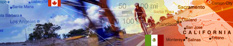
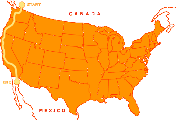
Canada
to Mexico 2005
Route
Details
Washington
and Oregon (by adventurecycling.org)
Along the Canada to Mexico Route, you'll get to see marine wildlife such
as sea lions, and as you pass you can hear them barking. Take the time
to watch as one by one they dive off their rocks in search of their daily
meal of fish from the ocean. During the peak tourist season, there is
heavy recreational vehicle traffic along U.S. Highway 101 along the coast,
so cyclists must ride cautiously and defensively. This route can be ridden
from early spring to late fall. Heavy winter rains can cause flooding
and mud slides and may close roads, especially along the coast in the
spring. Fog can also be a problem during any season. Due to changing local
conditions, it is difficult to predict any major wind patterns.
The route begins in Vancouver, British Columbia and heads south through
the suburbs of this large city. Farmlands appear before crossing the border
at Blaine into the United States, and you'll continue through more rural
country after entering Washington. After crossing Deception Pass, the
route is on Whidbey Island, where there is a large U.S. Naval Reservation,
and the loud noise of test jets flying overhead can be heard. There's
a pleasant ferry ride over to Port Townsend, which is back on the mainland.
The route then winds southward through a series of small towns on the
eastern side of the Olympic Peninsula. In Bremerton, if you're interested,
you can catch a ferry that takes you directly to downtown Seattle and
its attractions. You'll then head into logging country and see forest
plantations in various stages of development: recently clear-cut, newly
planted, middle-aged, or ready to be harvested. At Castle Rock, a five-mile
side trip leads to the Mount St. Helens Visitor Center, which tells the
tale of the volcano's eruption in 1981.
A short ferry ride crosses the Columbia River into Oregon to begin a magnificent
ride down the coast. You'll bike along the shoreline and headlands and
see mile after mile of spectacular scenery including lighthouses, craggy
coastal pines, and rock formations in the water. Innumerable parks dot
the coast and invite one to stop and take hikes down to the water for
tide pool viewing. Small towns are abundant and cater to the tourists
who invade the coast from spring to fall.
The route's terrain in Canada and Washington is flat to rolling hills,
with a few climbs. Biking along the Oregon coast means hills, and some
of them are steep, but it also means that your spectacular views will
be well-earned. Don't forget that your uphills on one side of a coastal
headland mean a downhill on the other side.
California
Coast
The curvy, winding roads along the Pacific Coast Route are shared with
farm and logging trucks, cars, and recreational vehicles, so extra caution
is needed by cyclists. There are bike paths in some of the large cities
the route goes through, and you'll need all your defensive urban cycling
skills to contend with the heavy traffic. But this is California, land
of sun and fun (especially along the southern portion of the route). Take
advantage and go jump into the Pacific on a whim or watch a beautiful
sunset. This route can be ridden at any time of the year, but spring and
autumn are optimal periods to avoid the increased tourist traffic in the
summer. And be forewarned: heavy winter rains can cause flooding and mud
slides and may close roads, especially along the coast. Heavy fog can
also be a problem during any season. Due to changing local conditions,
it is difficult to predict any major wind patterns, but during summer,
strong winds will prevail from north to south.
Soon after starting this route in Crescent City, you will be biking through
awe-inspiring redwood country on roads shaded by trees reaching high into
the sky. A herd of elk live near Orick and are usually easy to spot. The
redwoods are a big tourist area, so you'll have the opportunity to bike
through trees that most people drive their cars through. After leaving
the redwoods, you'll enjoy scenic riding along the Pacific Ocean, where
the route climbs and descends along the coastal headlands.
Biking over the Golden Gate Bridge into San Francisco is a real treat,
and the route stays on the western edge of the city. Heading southward
along the coast, there are numerous state beaches. If you're at the Año
Nuevo State Reserve during the elephant seal mating season in January,
viewing the seals is not to be missed. North of Monterey, acres of farms
begin to appear in the Salinas Valley, a prime agricultural area known
as the "Artichoke Capital of the World."
After leaving Carmel, the ride south along the Pacific Coast Highway is
the most spectacular portion of the route for many cyclists. This winding,
scenic road high above the Pacific has been seen many times in television
shows, commercials, and movies. Leaving the Santa Lucia Mountains and
the coast, it is evident that you've reached "southern" California.
You'll encounter many fertile farms and areas with various degrees of
development. Santa Barbara is an easy town to cycle through. When you
reach Malibu, you'll find tremendous congestion and view hundreds of trophy
homes built into the hillsides or along the beaches. This is the northern
end of the Los Angeles megalopolis.
Beginning in Santa Monica, the route uses some beautiful bike paths that
go right through the middle of the sandy beaches, and then you'll ride
through residential and industrial areas before rejoining the Pacific
Coast Highway south of the city. All the way to San Diego, there will
be a mix of urban cycling through towns, bike paths, highways, and shore
roads. Through San Diego and its suburbs, the route follows residential
streets and bike paths to the Coronado Pedestrian-Bicycle Ferry, which
takes you to Coronado and a bike path along Silver Strand State Beach,
then to the route's end near the Mexican border.
This route segment is generally hilly, with lots of ups and downs following
the coastline in the northern part of the state. Some sections in the
southern part of the route are rolling to flat, especially along the various
cities' bike paths along the beaches.
|